The Parramatta to Carlingford cycleway, map and photos of the construction
The Parramatta to Carlingford 5.7km cycleway has been constructed alongside the new Parramatta Light Rail and follows the former rail line from Carlingford to Camellia.

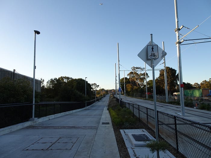
In recent weeks, workers from the Parramatta City Council have been adding the finishing touches to the cycleway by constructing signage, adding line markings and seating.

The cycleway is extremely wide, and is also accessible to pedestrians.

The cycleway starts just north of the Carlingford light rail stop, near Post Office Street.


The cycleway passes the light rail stops at Carlingford, Telopea, Dundas, Yallamundi, Rosehill Gardens and Tramway Avenue.

Yallamundi is located at the former railway station that was previously called ‘Rydalmere.’ Yallamundi is a Darug word meaning ‘storytelling” — which relates to the nearby university.


The Rosehill Gardens light rail stop was once the location of the Camellia railway station, which was known as ‘Subiaco’ before 14th September 1901.

The Parramatta to Carlingford cycleway follows the eastern side of the light rail route from Carlingford to Rydalmere. The cycleway crosses to the western side of the light rail route at Victoria Road Rydalmere.
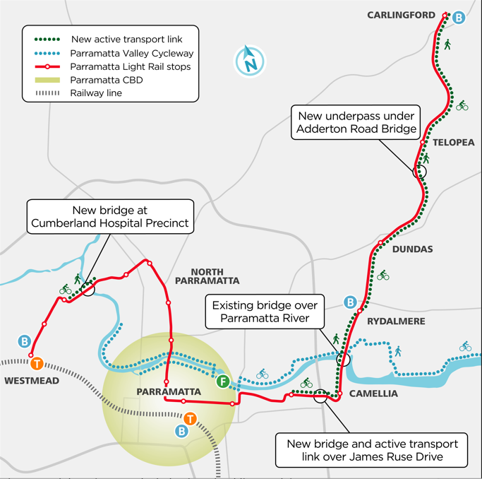
Some notable infrastructure features on the route that cyclists and pedestrians will appreciate are the 95 metre retaining wall south of the Pennant Hills Road bridge at Carlingford, an access tunnel at Adderton Road Telopea, the new bridge and on-ramp at Leamington Road Dundas, cycle access to the bridge over Kissing Point Road at Dundas, and for the first time, cyclists and pedestrians will be able to cross the Parramatta River from Western Sydney University into Camellia.


By far the largest piece of infrastructure on this route is the Bidgee Bidgee Bridge over busy James Ruse Drive at Rosehill. The mega arch bridge is 16 metres wide and 64 metres long, linking Camellia with the Tramway Avenue light rail stop.
The bridge is the second largest steel arch bridge in the state — behind the Sydney Harbour Bridge.

“For 20 years, Bidgee Bidgee led the Burramattagal clan of the Darug people, bringing all people together to help shape the region’s history. He was a city-shaping elder who was engaged as a tracker by Governor Macquarie and rewarded by being appointed ‘Chief of the Kissing Point tribe’” — NSW Government statement.


The light rail heads west from Tramway Avenue and ends at Westmead. Cyclists and pedestrians are funnelled onto the southern side Parramatta Valley Cycleway which starts near Noller Parade.


The cycleway is mostly flat, although there is a slight gradient while cycling north between Telopea and Carlingford.

When will the Parramatta to Carlingford cycleway open?
The responsible authority for the Parramatta to Carlingford shared pathway is the NSW Government. At the time of publishing this article, the team at the Parramatta Light Rail told me that electricians are still working at each rail stop, and the cycleway may open in Spring 2022. But, based on two conversations that I had with tradies that I met near the route, the Parramatta to Carlingford cycleway could be opened in late August 2022. Light rail services are expected to begin in 2023.


The Parramatta to Carlingford cycleway has accessible links to the Parramatta River Cycleway at Western Sydney University and the M4 Cycleway via Alfred Street at Harris Park.

The Parramatta City Council has previously stated that they’re exploring options to connect Epping to the Parramatta Light Rail “Active Transport Link” at Carlingford.
I hope you enjoy cycling this new shared pathway. I’m interested in hearing your thoughts about the route — drop me a note via social media at @BrendenWood.